Administrative Area Vector Tile Package
- API
Features
Vectorized Administrative Area Data
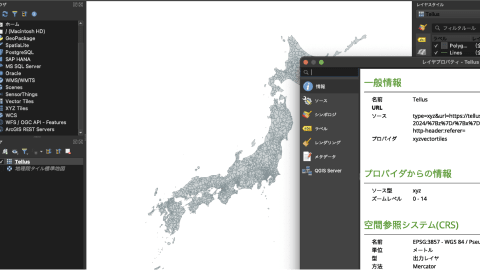
This is vector tiles of administrative area polygons. The tiles are distributed in url-template /{z}/{x}/{y} and you can integrate it to web apps or load in QGIS.
Administrative Area (Japan) - 2024: https://nlftp.mlit.go.jp/ksj/gml/datalist/KsjTmplt-N03-2024.html

Recommendations from our team!
This is the package which provides you “Vector tiles” available on Browser or QGIS.
Vector tiles enables large dataset to be broadcasted in nice performance.
Let’s use this and find new insights with Tellus Satellite Data and Ground data of this package.
Getting started
By starting to use the tool, you are considered to have agreed to the terms of use.
Step 1: Issue an API token
Create the authentication token required to execute the API. When executing the API, use it as {"Authorization": "Bearer {{issued API token}}"}.
API TokenStep 2: Execute by referring to the API reference
For specific endpoints by function, please refer to the API reference.
API Reference| Provider | MIERUNE Inc. |
|---|---|
| Terms of use | Terms of service | 国土数値情報ダウンロードサイト Privacy Policy | MIERUNE |
| Notes | In the case of distributing any products using data provided from this API, you must speficy an attribution, (e.g. 「国土数値情報(行政区画データ)」(国土交通省)を加工して作成」). |
| Environment in which tool can be used | Available outside of Tellus |
| User manual, API reference | - API reference |
| Changelog |