Tellus-Clairvoyant
- API
- QGIS Plugin
Features
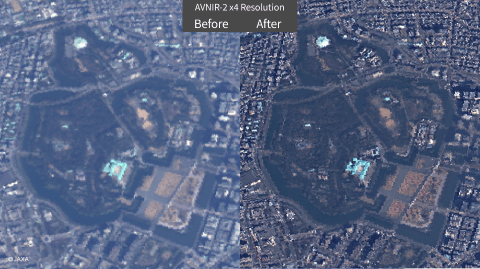
Enhance satellite image clarity
Tellus-Clairvoyant is a tool that uses deep learning technology to apply super-resolution processing to satellite images. The resolution can be enhanced up to 4 times, making blurry images appear clearer and objects easier to recognize by pseudo-enhancing the resolution.
This tool can be useful for creating AI-based image analysis models, helping to increase the amount and variety of training data, as well as improving the accuracy of the learning results.
Supported Satellites
- AVNIR-2: Optical sensor mounted on Advanced Land Observing Satellite "DAICHI" (ALOS)
- PALSAR-2: L-band synthetic aperture radar mounted on Advanced Land Observing Satellite-2 "DAICHI-2" (ALOS-2)

Easy operation with GUI
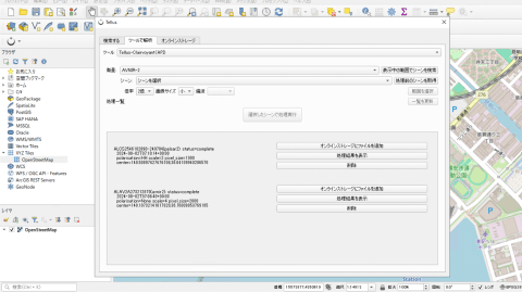
Tellus-Clairvoyant can be executed via API, but we also provide a plugin tool for QGIS. You can specify the area to analyze directly on the QGIS map and search for data. The results can be viewed as images on QGIS, making the analysis intuitive without the need to write code.
The QGIS plugin is available in the Tellus analysis environment, Tellus Satellite Data Master with QGIS. For more details on applying, please visit our Development/Analysis Environment page.

Getting started
By starting to use the tool, you are considered to have agreed to the terms of use.
Step 1: Issue an API token
Create the authentication token required to execute the API. When executing the API, use it as {"Authorization": "Bearer {{issued API token}}"}.
API TokenStep 2: Execute by referring to the API reference
For specific endpoints by function, please refer to the API reference.
API ReferenceStep 1: Subscribe to Tellus Satellite Data Master with QGIS
Subscribe to Tellus Satellite Data Master with QGIS, a remote analysis environment. Check the Development/Analysis Environment page for product lineup and payments methods.
Development/analysis environment pageStep 2: Use QGIS with Pre-installed Plugins
Connect to the remote environment and launch QGIS. The Tellus plugin tools are ready to use.
Target dataset
- AVNIR-2
- PALSAR-2
| Provider | Tellus Inc. |
|---|---|
| Terms of use | Tellus Service Terms and Conditions (PDF) |
| Notes | When you use analysis results, please describe "Original data provided by JAXA" and confirm the License Agreement of each satellite data. |
| Environment in which tool can be used | Available outside of Tellus |
| User manual, API reference | - API reference |
| Changelog |