Tellus-LFP (Learning From the Past)
- QGIS Plugin
Features
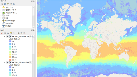
Automatically color GCOM-C SST and CHLA data
GCOM-C data is displayed in grayscale by default on QGIS, making it hard to interpret. Assigning appropriate colors to each value makes it easier to understand data, but this can be time-consuming if done manually. With Tellus-LFP, you can easily batch color-code the data.

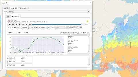
Display GCOM-C data in time series graphs
It is important for Environmental data like sea surface temperature from GCOM-C to detect changes over time.By setting monthly GCOM-C SST data in Tellus-LFP, you can select a point on the map to display its time series data. If you select an area, the average values within that area are automatically calculated and graphed, reducing the manual effort required for data analysis.

Animate Images Over Time
Tellus-LFP allows you to create animations from multiple scenes, making it easy to visualize color-coded data and track time-series changes simultaneously. This helps you visually understand the time-series changes in observations across the globe. You can download the generated images for use in presentations, expanding their utility.
Recommendations from our team!
By analyzing changes observed by satellites over the years, you can imagine future trends in Earth's environment. The name “Tellus-LFP” reflects our desire for this tool to be used for “Learning From the Past” to benefit the future.
By T.S (Tellus Inc.)
Getting started
Step 1: Subscribe to Tellus Satellite Data Master with QGIS
Subscribe to Tellus Satellite Data Master with QGIS, a remote analysis environment. Check the Development/Analysis Environment page for product lineup and payments methods.
Development/analysis environment pageStep 2: Use QGIS with Pre-installed Plugins
Connect to the remote environment and launch QGIS. The Tellus plugin tools are ready to use.
| Provider | Tellus Inc. |
|---|---|
| Terms of use | - |
| Notes | You need an agreement in advance for commercial use. Please inquire Tellus office. |
| Environment in which tool can be used | Tellus Satellite Data Master with QGIS |
| User manual, API reference | https://sorabatake.jp/37339/ |
| Changelog |